Interstate highways fundamentally reshaped the region, bringing growth to some communities while fracturing others. On the 70th birthday of the Edens Expressway – the state’s first modern highway – we take a unique, aerial look at the deep impact of this now-ubiquitous transportation infrastructure
West Garfield Park, before and after the Eisenhower Expressway
The Chicago region opened its first modern interstate—the Edens Expressway—exactly 70 years ago, five years before President Eisenhower signed the Federal-Aid Highway Act, and we in Illinois have rarely looked back, until now. In fact, Illinois has the third-longest interstate system of any state, only bested by California and Texas. These roads have had a tremendous impact on nearly every facet of life, but especially on the way we move and the way we build our communities.
The interstate highway system reflected a monumental shift in mobility. It was a colossal undertaking to build something completely new. For better or worse, it was revolutionary. Seven decades later, building and maintaining that system is still the dominant feature of transportation planning. For all the trillions spent, what have we really gotten? We’re all familiar with the experience of driving down the highway, but sometimes it’s helpful to get a bird’s eye view to really understand the impact of such massive features.
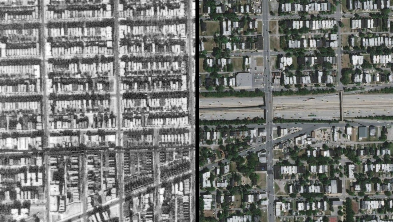
Lucky for us, we have an amazing statewide repository of historical aerial photographs spanning from 1937 to 1947, taken as part of the USDA’s Agricultural Adjustments Administration. The AAA was primarily concerned with changes to agricultural lands and soil condition, but the photographs also provide an incredible record of the pre-war built environment.
Use the image sliders below to compare the historic photos with modern satellite imagery.
Infrastructure investments reflect economic and social priorities
There’s an old adage in urban planning that to understand a city’s priorities, don’t listen to what its leaders say. ook at what gets done. That’s certainly on display in these images of the interchanges between the Stevenson and Dan Ryan Expressways in Chicago. What was once a dense and relatively connected urban neighborhood has been heavily fragmented and eroded. It’s a small miracle that neighborhoods like Chinatown survived at all. These highways were built to provide residents of distant, newly built suburbs with rapid auto access to the Loop, not to improve the access of people living on Chicago’s near south side. Many believe these routes were purposefully chosen to entrench the segregation of mostly white Bridgeport and Armour Square from mostly Black Douglas and Bronzeville.
Compare that to these images of Oak Brook near the interchange between I-88 and I-294. Here, the new rapid access to the region’s economic core allowed for explosive growth and new centers of wealth and commerce. Oakbrook Center, built in 1962, is the region’s second-largest shopping center in the region. Served only by a few limited bus routes, it’s .
Every investment has benefits and burdens
The inequitable distribution of the benefits and burdens of infrastructure has been well-documented, but it’s still powerful to see it up close. The images below show Englewood and Washington Park, two communities now divided by the Dan Ryan Expressway. Housing and population loss have been particularly devastating here. And while there is no single reason behind it, the negative impacts of the highways are a central part of the story. They’re a physical embodiment of the relentless extraction of wealth from the Southside.
If you keep traveling south on the Dan Ryan and take I-57 at the split, you’ll come to Oak Forest, where much of that extracted wealth settled. The highways allowed people to travel further faster, accessing cheap land where homes could be built affordably. , as has been so extensively documented, these opportunities were closed off to communities of color.
Proactive versus reactive planning
The interstate highway system, as originally conceived, was an example of proactive planning. Eisenhower wanted to build a network of roads to improve interstate commerce which could also be used for defense purposes. The idea of razing vast swaths of existing communities to bring interstates into the urban core, however, was a reaction to white flight and suburbanization. The outward migration from US cities came to be seen as an inevitability, and even desirable, so the system we see today was built to accommodate that movement. But by doing so, public officials created a self-fulfilling prophecy that continues to this day. This is vividly represented in images of the Eisenhower Expressway cutting through Garfield Park.
If you continue your trip west, you’ll eventually come to Downers Grove. While Downers Grove has been connected to Chicago by rail for over a century, it didn’t experience rapid growth until the highways were built. Today, it’s an incredibly prosperous bedroom community.
Is it time for the next mobility revolution?
It’s easy to overlook the monumental impact that highways have had on the region as we zip along them each day. Especially to younger generations, it seems like they’ve just always been here. But when seen from above, a new view offers an opportunity to reflect on where we’ve been and where we’d like to go. The interstate system was a revolutionary change to mobility, with very real benefits and burdens. There’s a lot of interest in beginning to undo the harms brought by massive highway construction. For the first time ever, the federal government is considering funding not just highway construction, but highway removal. The new administration in Washington brings new opportunities. What future would we like to build, and is it time for the next mobility revolution?