Newly announced trail investments in Chicago are bringing the city closer to having continuous riverfront trails. Many of the forthcoming improvements build on projects led by Great Rivers Chicago partners.
Jay Koziarz, Curbed Chicago
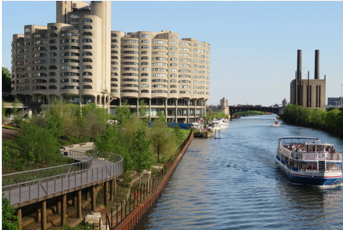
Public riverwalk at Southbank development, at Harrison and the Chicago River.
Continuous riverfront trails have long been a dream for Chicago’s river (and bike!) enthusiasts. Our Great Rivers calls for river trail gaps to be identified and filled by 2030. The City of Chicago’s newly announced vision for a connected citywide trail network takes us one step closer toward achieving this goal.
Nine of the twelve ‘key projects’ that will kick off implementation of the $15-million vision are river-adjacent trails. Several of these plans build opon work seeded through the Chicago Community Trust’s (CCT) Our Great Rivers grant, ideas proposed in the Our Great Rivers vision, or ongoing projects being led by organizations that are also members of the River Ecology & Governance Task Force. Taken together, these projects show the continued momentum of the Great Rivers Chicago initiative and the growing interest of the public and the City in riverfront revitalization.
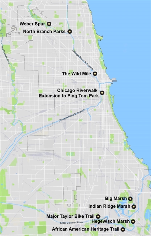
The nine riverfront trail projects are described below, alongside a map of their locations, ordered from North to South:
MPC
- Weber Spur: The project will connect trail gaps along the North Branch of the Chicago River. Active Transportation Alliance has been a long-time advocate for improvements along this corridor as part of its Chicago River Trail campaign.
- North Branch Parks: A collection of parks in Albany Park, along the North Branch of the Chicago River and the North Branch Channel, will receive waterfront and trail improvements. The investment will benefit nearby neighborhoods and build on the Confluence project, an economic corridor revitalization vision being led by the North River Commission, and supported by CCT’s Our Great Rivers grant.
- The Wild Mile: This floating boardwalk is beginning to transform the North Branch Canal into an in-stream wetland park. The concept was featured in the North Branch Framework Plan and Our Great Rivers, and the project lead, Urban Rivers, is a member of the River Ecology & Governance Task Force.
- Chicago Riverwalk extension to Ping Tom Park: This riverfront corridor was the focus of the 2017 Chicago River Edge Ideas Lab, in which nine world-class architecture firms developed concepts for public space and trail connections at three locations along the South Branch of the Chicago River. The Riverwalk extension would end at Ping Tom Park, the site of the highly-instagrammable murals and park improvements created by the Coalition for a Better Chinese American Community (CBCAC) and Ping Tom Park Advisory Council, funded by CCT’s Our Great Rivers grant. The riverwalk extension will bring more visitors to small businesses in Chinatown.
- Big Marsh & Indian Ridge Marsh: These two sites sit near Lake Calumet and the Calumet River. Trail connections would create a continuous trail from Pullman National Monument, the bike park at Big Marsh, down through Indian Ridge, and ending at Metropolitan Water Reclamation District SEPA station #1 at the river’s edge.
- Hegewisch Marsh: This natural area sits along the Calumet River, and boasts nearly 130 acres of native wetlands, marsh, and prairie habitat. New trails and habitat restoration within the marsh will allow even more visitors to experience wildlife and beauty at this site.
- African American Heritage Trail: This land-and-water trail highlights significant sites along the Little Calumet River related to the area’s rich African American history. The trail starts near Beaubien Woods in Riverdale, Chicago. The project is being led by Openlands and supportive riverfront leaders, and has received funding from CCT’s Our Great Rivers grant. Check out the project’s recent feature in New York Times’ 52 Places for a Changed World.
- Major Taylor Bike Trail: Named after the first African American world champion cyclist, Marshall “Major” Taylor, this trail crosses the Little Calumet River. In 2017, a group of community partners were funded by the CCT Our Great Rivers grant to create a 400-foot mural recounting Major Taylor’s triumphs. The mural gained national attention, and Major Taylor Trailkeepers has continued to advocate for improvements along the trail, including signage, trail maintenance, and rest areas.
To read more about ongoing riverfront projects, visit the Explore Our Great Rivers story map. For more riverfront news, sign up for Great Rivers Chicago updates (scroll down to the bottom).