
Cities like New York, Atlanta, Chicago and Washington, D.C. are investing in urban trail development.
Cities are evolving for the 21st Century. As industries cleaned up or left altogether, planners and city officials are strategizing around the best use for linear corridors that formerly transported materials from production to market. Trails and greenways offer a popular reuse and make good sense. The benefits of urban trails are well documented: They provide comfortable places to walk, run and bike without conflicting with auto traffic and they help people incorporate physical activity in their day-to-day activities. Trails provide an alternative mode to driving, so not only are users being physically active while doing things like commuting to work, but they are reducing wear and tear on the roads, emissions and traffic.
In and around Chicago, trails are wildly popular. The 26-mile south suburban Cal Sag trail saw 80,000 riders last year and Chicago’s Lakefront Trail, which connects 13 Chicago neighborhoods, hosts 30,000 visitors daily. The Lakefront Trail has become so congested that the Chicago Park District is currently in the process of building two major projects to accommodate usage: a new flyover at Navy Pier and parallel paths to separate cyclists and pedestrians. Chicago’s newest trail, the 606, saw about 1.6 million users in 2016. Additionally, construction for El Paseo connecting Pilsen and Little Village is underway and the Englewood Line is currently being planned.
The South Branch of the Chicago River is Chicago’s next trail frontier. Last August, Mayor Emanuel, in partnership with the Metropolitan Planning Council, Friends of the Chicago River, CMAP and many others released Our Great Rivers, a vision for the future of Chicago’s rivers. Over 6,000 individuals participated in developing the vision, which calls for a “continuous riverfront trails by 2030”. While there is a significant amount of trail on the North Branch of the Chicago River, the South Branch offers immense opportunity to connect neighborhoods and resident to the rivers and to each other, while providing trail connectivity to downtown and beyond. Currently, nine leading architects are exploring concepts to bring public access and a unified design aesthetic to the river with the River Edge Ideas Lab, which launches on September 16 in conjunction with the Chicago Architecture Biennial.
While this is an incredible opportunity to open up and redefine our rivers, we must be diligent in considering how public investments like new segments of river trail could lead to increased property values, which might burden local residents. Last year, DePaul’s Institute for Housing Studies measured the impact of the 606 to homes within ½ mile of the 606 from 2000 to 2016. The study analyzed home prices in the 606 West geography (the Humboldt Park area) and 606 East geography (the Bucktown area) and shows that once the project broke ground, home prices in 606 West increased by 48.2% while 606 East only increased by 13.8%. Such a drastic increase in property values, while often seen as a positive impact, can “be disruptive for senior homeowners on fixed incomes or for lower-income owners who are already paying a substantial portion of their incomes for housing,” as outlined in the study. This burden can also be translated to renters as increased market demand often leads landlords to make investments in their properties that appeal to higher-income earners.
Land use patterns also factor into the equation. A significant difference between the 606 and the South Branch of the Chicago River is that, in the case of the 606, residential property is adjacent to the trail and the study captured all residences within ½ mile. Along the South Branch, there are just a few blocks of residential development close to the river and the only residential development adjacent to the water is on the east side of Bubbly Creek, due to the existence of vast industrial and I-55 corridors.
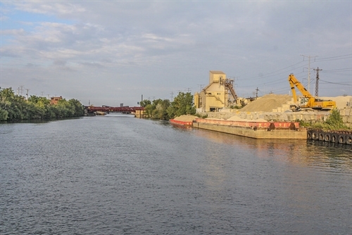
Residential neighborhoods are separated from the river by industry and the I-55 corridor along the Chicago Sanitary and Ship Canal.
Some cities simultaneously invest in new trails while proactively deploying anti-displacement strategies. In Atlanta, the soon-to-be-completed West Side Trail, which is part of the Beltline, is being paired with an anti-displacement strategy to help keep residents in their homes in the face of rising property values. The West Side Future Fund is available to residents in specific West Side neighborhoods to offset increased property taxes. The program is dependent on private donations. Delta Air Lines, the Chick-Fil-A Foundation and Georgia-Pacific have signed on to help.
In Washington D.C., with planning for redeveloping the Anacostia River moving forward, the Local Initiatives Support Corp. (LISC) has announced a “$50 million commitment to ensure the project does not spur widespread displacement of residents.” This development goes beyond a trail and includes projects like an outdoor plaza, amphitheater and environmental education center. LISC will direct the funding to local organizations that will provide direct supportive services like early childhood and arts education, medical care and food support to existing residents.
Back in Chicago, as trail planning advances along the Chicago River, MPC will learn from creative and innovative anti-displacement examples across the nation to balance public investment with neighborhood preservation.