
Riders board the Water Taxi at Ping Tom Park.
 By Natalie Hamilton, MPC Research Assistant
 - August 31, 2017
When people think of waterfront recreation in Chicago, they think of Lake Michigan. Rarely do locals consider the Chicago River a place to spend quality outdoor time. After all, over the past century, large stretches of the waterway have been concealed from the rest of the urban grid by factories, warehouses and other industrial spaces.
But unbeknown to many Chicagoans, the North and South Branches of the Chicago River offer not only manufacturing and industry, but impressive parks and natural areas. MPC and its Great Rivers Chicago initiative has created Story Maps of the wonderful, noteworthy and too-often undervisited sites along the river. These Story Maps, which were created using ESRI software, for both the North Branch and South Branch offer in-depth information and details about CTA bus and train routes to the parks so you can easily figure out how to reach your destination via public transit. (Check out Story Maps later this summer for the Calumet and Des Plaines Rivers!)
So start exploring! Here are a few highlights from our Chicago River Story Maps:
North Branch
Along the river, north of the North Branch Industrial Corridor, lies an abundance of green space and natural areas.
La Bagh Woods is located far north on the North Branch. Even though this site is within the boundaries of Chicago, you feel as though you are well beyond the city limits. It’s not your typical landscaped park but rather a completely natural area where the trees, shrubs and grasses are free to grow as they please. The North Branch wanders through the wooded area and for the most part still contains its natural riparian border and not the steep man-made banks that are found elsewhere along the river. This makes getting the the river's edge a whole lot easier.
Eugene Field Park is south of La Bagh Woods, along the North Branch. Located in Albany Park, this space is dissected by the river, and the north and south sections are connected by two pedestrian bridges. The north section contains a restored wetland and a prairie ecosystem, while the south section contains a fieldhouse and a paved trail that runs along the river.
Von Steuben River Edge, located slightly southwest of North Park University in Kawanis Park, is another must-see spot on the North Branch. Von Steuben River Edge is a linear park that allows visitors direct access to the water via a stone terrace. This is the perfect spot to enter the water if you have your own kayak or canoe or if you don’t own either of these, it’s also the perfect place to sit and relax with your feet in the water.
There are many other parks along the North Branch, such as River Park, Horner Park and Ronan Park that are full of amenities and places to explore. Use the North Branch Story Map to learn more. Next let’s move to the South Branch.
South Branch
Although the South Branch of the Chicago River is heavily industrialized, there are some amazing green spaces hidden among the factories and warehouses.
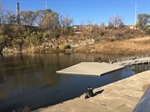
Ping Tom Park is a pleasant addition to Chicago’s thriving Chinese community. This spot, with its interesting architecture and landscape design offers a quiet, contemplative space away from the busy shopping districts of the neighborhood. The park provides two direct-access points to the river and is a stopping point on the Chicago Water Taxi route.
Palmisano Park is not located directly on the South Branch because it lies about 1/4 mile south of the river in the Bridgeport neighborhood. This just may be my favorite park in the city! We all know that Chicago is painfully flat (geographically speaking) but this park contains an actual hill. One of a few in the city! So climb the prairie grass-covered hill via several paths and enjoy the view from the summit. Palmisano Park was once a limestone quarry that reached 380 feet below street level. After the quarry closed, it was filled with stone, brick, wood and other construction materials over the years before it was redeveloped and opened as a park in 2009. You can still descend about 40 feet below street level using metal grated walkways, and at the bottom you will find a catch and release fishing pond.
Moving further south, you will find two parks that lie on the east and west side of S. Ashland Avenue on the south bank of the South Branch. Since the industrial spaces along the South Branch extend about a ½ mile in both a north and south direction from the river both the Canalport Riverwalk and Canal Origins Park are fairly secluded from the surrounding neighborhoods. So if you are looking for some quiet time, these spots are ideal.
Canalport Riverwalk (on the west side of Ashland) is a linear park that is lined with fishing stations and offers some interesting views of a scrap metal yard.
Canal Origins Park (on the east side of Ashland) is a triangular shaped piece of land that juts into the South Fork of the South Branch providing a striking panorama of the Chicago skyline. This park, which commemorates the construction of the Illinois and Michigan Canal, also contains several fishing stations. This part of the river is considered one of the top fishing habitats in the city.
Additionally, new developments like Riverline and Related Midwest’s “The 78” promise to incorporate more riverside parks into their site designs, which will be available for the public to enjoy. Plus, recently passed zoning changes in the North Branch Industrial corridor will allow for mixed-use development, which has long been excluded from this area. So amidst the concrete and steel of the city, Chicagoans may soon find additional riverside green spaces.
Try our Story Map tool for both the North Branch and South Branch! Get out and about! Engage with your river. These gems may require a little effort to reach but they’re worth it. And they’re waiting for you.