
Flickr user CTA (cc).
CTA's new Cermak-McCormick Place Station on the Green Line offers plenty of opportunity for new development.
 By Yonah Freemark and MPC Research Assistant Mengwei Sun
 - August 17, 2015
Over the past few years, Chicago has invested in three new “infill” stations located along existing ‘L’ tracks, filling service gaps between stops and expanding access to the transit system. The Chicago Transit Authority ‘L’ has seen dramatic ridership increases over the past 10 years, increasing 29 percent from 474,478 average weekday boardings in 2004 to 614,220 last year—and some of that change can be attributed to these new stations, which are attracting more riders and creating opportunities for transit-oriented development.
The infill station added riders to the transit system and created new opportunities for mixed-use development.
The CTA opened two stations in 2012, one at Morgan Street on the Green and Pink Lines and one at Oakton Street on the Yellow Line. The Morgan Station has been particularly effective in bringing new development to the West Loop and now attracts more than 2,300 daily riders as of March 2015.
In February 2015, CTA added another station at Cermak Road on the Green Line near the McCormick Place convention center in the South Loop neighborhood. The stop cost $50 million to build and was completed by the Chicago Dept. of Transportation using tax increment financing funds. It filled what had been a 2.5-mile gap between the Roosevelt Road and 35th Street stations on the line.
Cermak-McCormick Place station is already attracting additional ridership
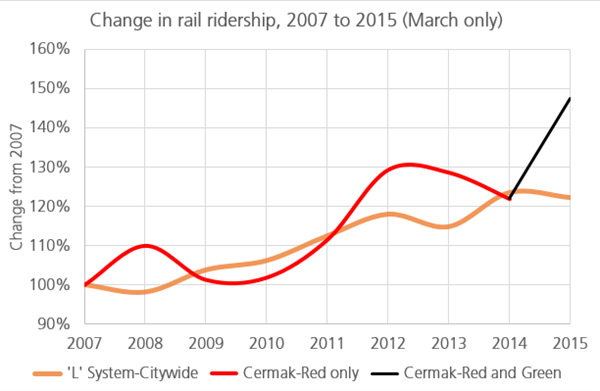
Though the station is virtually brand new, initial ridership figures for March 2015 released by the CTA already point to the benefits of the new station in growing ridership and producing neighborhood growth. The Metropolitan Planning Council conducted this preliminary review on the effects of the station so far by comparing ridership in the area in the month of March between 2007 and 2015.
Comparing March 2007 and March 2014, ridership at the Cermak-Chinatown station, a stop on the Red Line about a quarter-mile to the west, generally tracked changes on the ‘L’ system as a whole, increasing about 20 percent over that period, as the following chart shows.
Once the Cermak-McCormick Place station was added in early 2015, however, the ridership at that plus the Cermak-Chinatown station increased, despite the fact that overall ‘L’ weekday boardings in March 2015 were actually slightly lower overall than they were in March 2014. While there are variable effects such as weather to consider, and it is still early to draw firm conclusions, this indicates that the new station may be attracting additional riders to the system as a whole, not just moving people from one station to another.
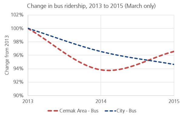
Nor does it appear that the opening of the new station has moved people away from nearby bus routes, as the following chart shows. Several bus routes that stop near the Cermak-McCormick Place station, including the 1, 3 and 4 buses, run roughly similar routes to the Green Line as they run north-south into downtown. So a new train station could have theoretically moved people away from those lines and onto the ‘L.’
Yet, while ridership on those lines actually fell more than the CTA bus average between 2013 and 2014, they increased between 2014 and 2015 (March only), even as CTA bus ridership continued to fall. So the addition of the new station not only seems to have contributed to increased overall rail boardings in the Cermak Red and Green Line area, but it also does not appear to have reduced bus route use in the surrounding area.
Further analysis of the ridership impacts of the Cermak-McCormick Place station are necessary in the coming years to confirm these trends. But so far the evidence available suggests that the station is doing its part in increasing the transit system’s ridership.
Land use and zoning
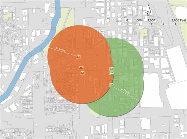
Despite the fact that it is close to the Cermak-Chinatown station, the Cermak-McCormick Place station does offer a significant area of the South Loop neighborhood much better access to the ‘L’ system, particularly in areas to the south and east of the new station’s entrances.
The following map shows the land within a quarter-mile of the Cermak-Chinatown station (in orange), and the additional land within a quarter-mile of the Cermak-McCormick Place station (in green). The new station increased the amount of land in the neighborhood within a quarter-mile, or about a five-minute walk, of the ‘L’ by about 60 percent. It also made the convention center more accessible for visitors using the transit center and opened up access for the burgeoning “Motor Row” area.
Existing land use and zoning regulations in the area newly accessible to the rail system suggest that the station has the potential to spur major new real estate investments in the form of dense, mixed-use transit-oriented development.
Data provided by the Chicago Metropolitan Agency for Planning on land use in the area show that the new station roughly doubles the amount of vacant land accessible by transit in the surrounding neighborhood, in effect adding almost 400,000 sq. ft. of developable land, as shown in the following table and map. If this land were developed at a typical downtown density, about 1,500 apartments could fit—enough to house more than 2,000 new residents in the community.
Summary of land use, 2010 (source: Chicago Metropolitan Agency for Planning)
|
|
Cermak-Chinatown Red Line station (sq. ft.)
|
Cermak-McCormick Place Green Line station (sq. ft.)
|
|
Residential
|
2,291,440
|
524,127
|
|
Commercial
|
761,452
|
1,171,656
|
|
Institutional
|
388,804
|
120,654
|
|
Industrial
|
4,978
|
206,556
|
|
Trans/Comm
|
901,316
|
452,819
|
|
Open Space
|
106,820
|
109,923
|
|
Under Construction
|
1,869
|
-
|
|
Vacant
|
398,858
|
377,961
|
|
Total
|
4,855,537
|
2,963,696
|
Land use (2010) within a quarter-mile of Cermak Red and Green Line stations
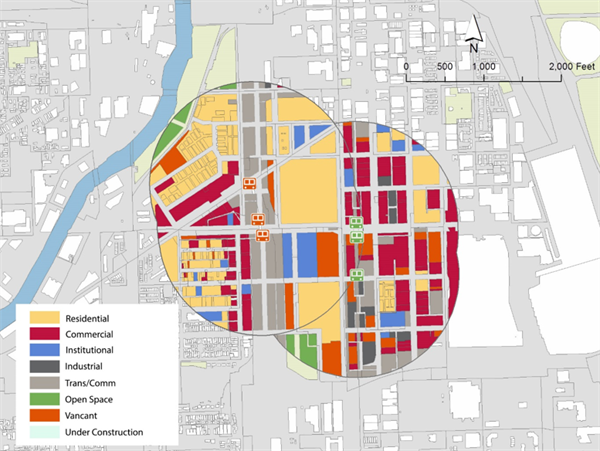
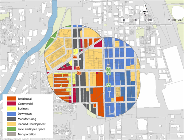
As the following table and map illustrate, more than two-thirds of land within the newly Green Line-accessible area has a “Downtown” zoning designation—quite a change from the land within a quarter-mile of the Cermak-Chinatown Red Line station. This “Downtown” designation allows dense, mixed-use buildings that combine offices, apartments, retail and other needs—exactly the type of new building needed for areas near transit.
The heavy concentration of downtown-zoned land near the new Cermak station makes it an excellent place to build new transit-oriented development, in some cases on vacant land, in some cases by building on surface parking lots and in some cases by replacing single-story and underused structures.
Summary of parcel zoning, 2014 (source: City of Chicago)
|
|
Cermak-Chinatown Red Line station (sq. ft)
|
Cermak-McCormick Place Green Line station (sq. ft.)
|
|
Residential
|
895,708
|
312,589
|
|
Business
|
259,772
|
-
|
|
Commercial
|
316,289
|
-
|
|
Downtown
|
240,560
|
2,101,808
|
|
Manufacturing
|
827,857
|
108,089
|
|
Planned Developments
|
2,179,325
|
437,475
|
|
Parks and Open Space
|
106,820
|
-
|
|
Transportation
|
29,185
|
3,663
|
|
Total
|
4,855,516
|
2,963,624
|
Zoning within a quarter-mile of Cermak Red and Green Line stations
Together with the increase in ridership the station is already generating, the Green Line stop will likely generate significant new development, as has the new station at Morgan. For Chicago, that’s great news, since it means more people living and working in environmentally friendly and congestion minimizing areas near transit.