A new tool will help public agencies quickly and easily understand how people are traveling, and where the greatest opportunities for improvement are, so transportation dollars can be used most effectively.
We all know the region’s streets are crowded and can be chaotic. And new modes keep entering the system--scooters, anyone? But what tools do we have to see how all the elements of transportation are working together? How do we know if the policies we put in place are actually helping people get where they need to go faster, more affordably, or more safely?
Replica, a transportation analysis tool and newly independent company spun off from Google affiliate Sidewalk Labs, incorporates new data and visualization methods to support improved multimodal analysis and regional collaboration. Here’s why that matters:
A major tool for planning future transportation has always been travel demand models. They forecast how we’ll use our transportation system in the future and how people will change their behavior when a new transportation project is built. The tools we use today were built in the 1950s mainly to evaluate the highway system, and despite periodic upgrades, they have major limitations.
The primary transportation model used in the seven-county region is a trip-based model designed to analyze changes in driving behavior as a result of large roadway or transit projects, such as the Jane Byrne Interchange reconstruction or the Red Line extension. This is what was used to test the regional projects in the ONTO 2050 long range plan. While the model does provide transit ridership forecasts, our region’s transit agencies use a different model favored by the Federal Transit Administration, which means the transit ridership forecasts are coming from a different source than the auto trips. These models do not work well for smaller improvements at a community level; they are mainly for large regional projects.
Additionally, it’s important to consider what data these models are using. Regional travel demand models depend on large and expensive household travel surveys such as this one that just wrapped up. They undergo a major update typically only once every decade, with some minor adjustments in interim years.
Today’s transportation sector is evolving really fast. Just think, Divvy bikeshare and Lyft have been operating in Chicago for only six years. Chicago Metropolitan Agency for Planning (CMAP) is in the process of developing a new version of travel demand model – an Activity-Based Model – that looks at a person’s travel throughout a whole day, versus the older style of analyzing each trip separately. This model more successfully addresses bike and walk trips and incorporates data on Lyft and Uber. As with other traditional models, however, it’s a complex program that only skilled professionals can operate and is not directly useable by city, county, or transit agency staff, or advocacy organizations. And it can take three days to run one potential transportation scenario.
The bottom line is: we need more options for high quality, nuanced and accessible information to determine how to spend our limited transportation resources.
The good news is the Chicago region is about to get a new tool: Replica. Two years ago MPC invited Sidewalk Labs (now Replica) to come to town to chat with a range of transportation planning stakeholders about a new tool that enables more granular and multimodal analysis using a wider range of data sources that are updated more frequently. Discussions involved the CMAP, Illinois Department of Transportation (IDOT), the Regional Transportation Authority (RTA), County DOT directors, the City of Chicago, and advocates including MPC, the Active Transportation Alliance, Center for Neighborhood Technology and the Environmental Law and Policy Center. As a result of those discussions, IDOT contracted with Replica to develop a Chicago-region version of the model. Ultimately the goal is for this tool to be available statewide.
Replica uses anonymized location data to give planning agencies a comprehensive portrait of a full set of baseline travel measures that are very difficult to collect and maintain today, including the total number of people on a highway or local street network, what mode they’re using (car, transit, bike, or walking), and their trip purpose (commuting to work, going shopping, going to school, etc.). The tool will also include estimated demographic information like age, income and race for users of different types of transportation. Because these metrics will be updated every three months, Replica also provides the ability to monitor changes over time, helping planners answer questions about land use and transportation ranging from a regional level to a city block. It will help the region understand how transportation choices are made, and where we might be able to influence them. For instance, Replica will enable a planner to choose a location with a concentration of jobs, such as an office park, on a map and determine where workers are traveling from and what transportation modes they use.
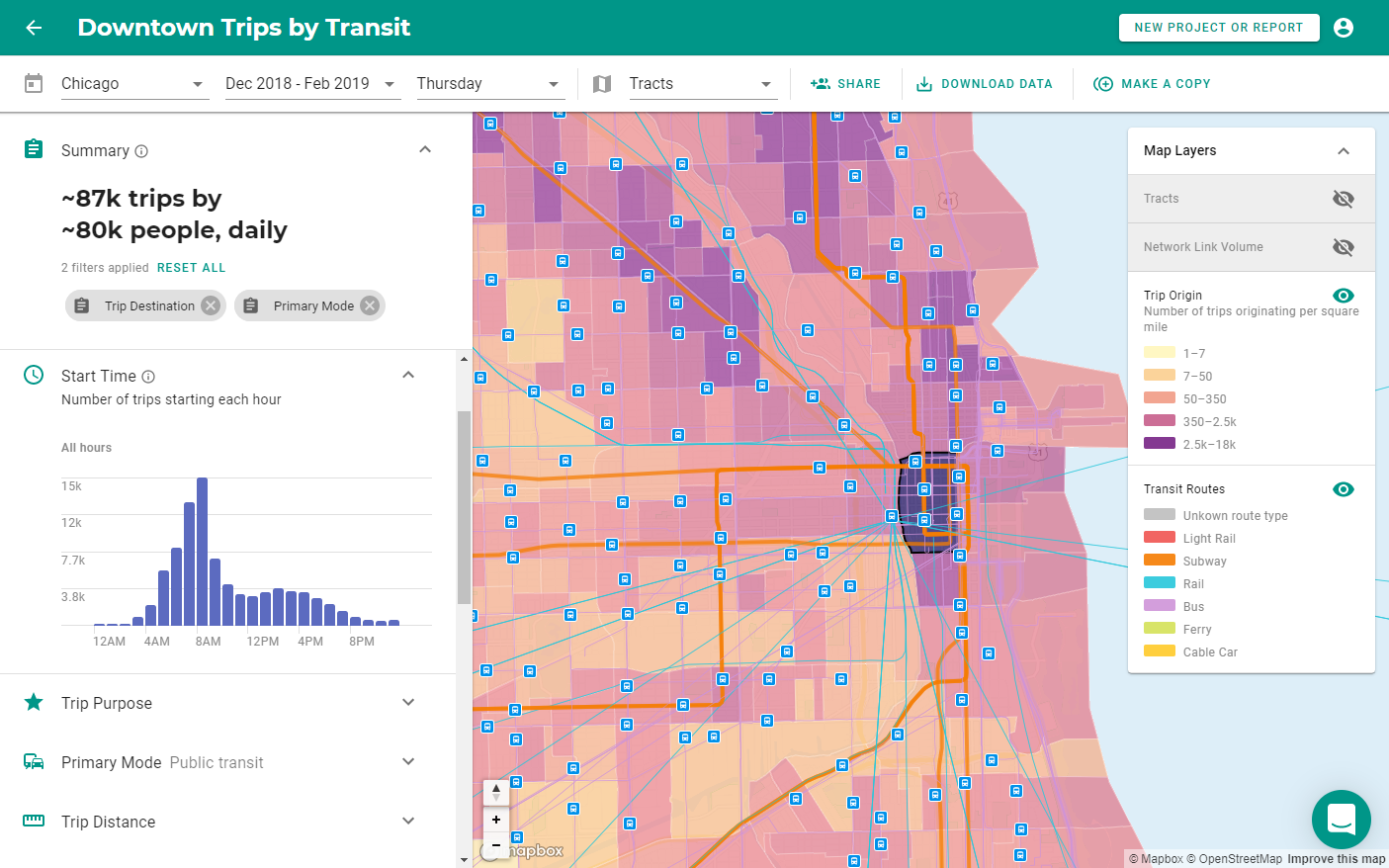 Image courtesy of Replica.
Additionally, this tool will improve our understanding of policy outcomes and planning decisions to inform future investments. We’ll be able to look at changes in travel behavior over time and better understand the outcomes of policies such as changes in parking costs or taxes on ride-hailing trips. The ability to measure changes in usage patterns before and after implementing a protected bike lane could help planners show how many more bike trips a new lane encouraged, making it easier for local officials to support similar interventions elsewhere.
This new tool is intended to facilitate collaboration, as each public agency in the region will be able to use the same baseline data. The result? Reduced barriers to access and a common framework for planning. Provided as a browser-based web-service, public agencies without extensive computer processing capabilities will be able to access the system, in contrast to the current format where models require massive computational power.
The Chicago-region’s first version of Replica has just been developed. We’ll be one of the first to have a regionally customized version of the tool, after Kansas City. Replica’s dashboard-style interface will help engage more people in planning decisions using transparent and visual models. There is no better time than now, with new transportation resources on the way with the recently passed capital bill and a quickly-changing technological and transit landscape, to have more sophisticated, flexible, and accessible tools to inform how we spend our transportation dollars.