When the Forest Preserves looked to expand its land holdings, MPC joined an innovative team in assessing the environmental, social, and equity impacts of various acquisitions. The data-driven process just won its second award. Here’s how it worked.

Bruce Bondy
A drawing showing a possible future Forest Preserve trail along Deer Creek, with residents exercising on a sunny day.
Even before COVID-19, the Forest Preserves began considering how it could expand more equitably.
Now more than ever, Cook County residents are appreciating our Forest Preserves as a lower-risk way to get outside, stay active, and take our minds off of COVID-19 for a few hours. But not all communities across the county have easy access to the Forest Preserves or other well-managed public green space. COVID-19 has also brought more attention to continuing problems that many marginalized communities are facing, such as repeated residential flooding and chronic diseases. The Forest Preserves of Cook County sees the opportunity to bring its benefits to more people and address some of these problems while putting health and racial equity at the forefront.
Even before COVID-19, the Forest Preserves began considering how it could expand more equitably. In 2014, the Forest Preserves released the Next Century Conservation Plan which lays out an ambitious goal to expand their holdings by about 30% – from about 69,000 to 90,000 acres of permanently protected land. Specific targets in the plan include developing long-term community partnerships in underserved communities, programming activities that emphasize health benefits, and making the Forest Preserves inviting and accessible to all. Then came two 2018 reports that both recommended a focus on racial equity in governmental decisions and policies: Cook County’s Policy Roadmap: Five-Year Strategic Plan for Offices Under the President and MPC’s Our Equitable Future: A Roadmap for the Chicago Region. With this backdrop, the Forest Preserves decided it was time to dig more deeply into its land acquisition options in Southeast Cook County and put out a request for teams to help develop a plan.
The Conservation Fund – a conservation-focused nonprofit organization based out of Arlington, VA – assembled a team in September 2018, including MPC, Antero Group, and Rudd Resources. In creating the Southeast Cook County Land Acquisition Plan, our team posed the question: Is there a way to plan for land acquisition that considers ecological quality as well as improving racial equity, flooding, and community health?
Protecting More With Less
Our planning process employed the Logic Scoring of Preference methodology outlined in the book, The Science of Strategic Conservation: Protecting More with Less. (Full disclosure: one of the book’s authors was a member of our project team.) The book provides an example of purchasing wine with $100. Whereas you can buy an outstanding bottle of wine for $100, the same money can buy four “very good” bottles. Applied to land conservation, the “outstanding” parcels (those that are already ecologically pristine and ready to be acquired) are rare. Instead, focusing on finding the “very good” parcels can result in surprising opportunities to achieve the same goals on a larger scale. Indeed, using creative criteria beyond the ecological value of the land allows the Forest Preserves to meet social goals as well as simple acreage expansion goals.
Can you imagine driving around to assess 80,000 individual parcels?
By employing the Logic Scoring of Preference method, our team examined more than 80,000 parcels encompassing approximately 62,000 acres. From among these, we presented the Forest Preserves with a portfolio of suitable parcels which—if acquired, restored, and programmed—would generate benefits including improved health, equity, and economic development opportunities, while meeting the Forest Preserves’ mission to expand their natural land holdings for education, recreation, scenic beauty, and protecting and preserving the flora and fauna.
How we did it
Can you imagine driving around to assess 80,000 individual parcels? Thankfully, we employed a computer-based approach. Five scenarios were developed to help differentiate potential parcels based on their ability to fulfill a set of objectives for the Forest Preserves:
- Ecological Value
- Flood Mitigation
- Adjacency to existing Forest Preserves holdings
- Connectivity to streams, trails, and other assets
- Equity/Social Vulnerability
Each of these scenarios was comprised of multiple datasets. For example, the Flood Mitigation scenario consisted of layers representing local hydrology (rivers, wetlands, etc.), 100-year flood zones, stormwater inundation maps, the Regional Flood Susceptibility Index, Chicago Wilderness’ Green Infrastructure Vision, and more. By acquiring parcels with known flooding issues, the Forest Preserves can prevent future floods by limiting development on the land. Similarly, the Equity/Social Vulnerability scenario applied the Centers for Disease Control and Prevention’s Social Vulnerability Index to identify those areas of the region most at risk for poor health outcomes and social discrimination due to factors such as race and ethnicity, socio-economic status, and lack of access to resources like housing and transportation (thus, those that could benefit most from well-managed and inclusive green spaces).
There was a complex weighting system that was informed by a robust public engagement process, but the basic idea was that a parcel received one point if it met the criteria for a scenario. Parcels that scored the highest were flagged for further investigation. This scoring methodology created a quantitative, replicable, and transparent decision-making framework for the Forest Preserves to identify possible land for expansion while taking both ecological and social criteria into account.
Bruce Bondy
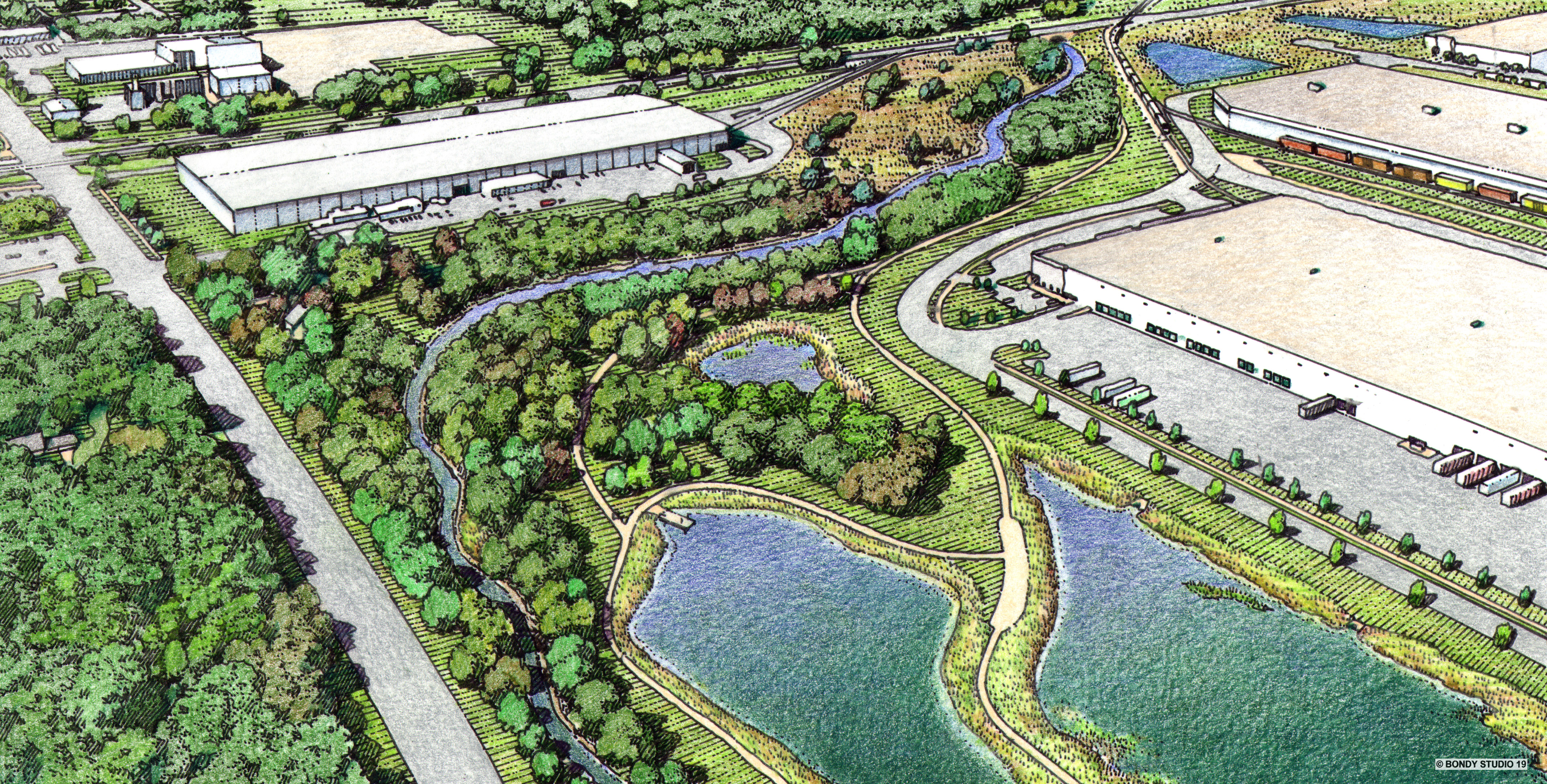
A drawing showing a future connected Forest Preserves corridor with stormwater features that prevent flooding and offer beauty and recreation.
Implementation of this long-range plan
The cost to acquire all of the recommended parcels within even a small subset of the planning area would cost between $45 million and $60 million if directly purchased, well beyond the Forest Preserves’ current budget. Given the reality of resource constraints, the plan included a Feasibility Assessment that considered on-the-ground opportunities to collaborate or partner in innovative ways to accomplish the broader land acquisition goals.
Our team explored a combination of cooperative management agreements, innovative collaborative partnerships, multiple-use strategies, and financing mechanisms. Plan recommendations include developing collaborative relationships with both traditional and non-traditional partners for the Forest Preserves, including exploring economic development synergies with municipalities, agricultural conservation easements, regional stormwater management with the Metropolitan Water Reclamation District of Greater Chicago, solar project developers, private sector collaboration, a stormwater credit trading marketplace, and more.
A good plan gets some recognition
MPC was honored to work with The Conservation Fund, Antero Group and Rudd Resources on this innovative plan, and this team is doubly honored to have recently received some external recognition:
- The Southeast Cook County Land Acquisition Plan received Friends of the Chicago River’s 2020 Green Ribbon Award for projects that demonstrate a high level of river-sensitive design and consideration; and
- The plan was awarded the Illinois chapter of the American Planning Association’s Healthy & Active Community Award for efforts to create healthier and active communities through a plan or program.
We thank Friends of the Chicago River and the Illinois chapter of the American Planning Association for these awards. And, of course, we would like to thank the Forest Preserves of Cook County for the opportunity to support this land acquisition process and for their commitment to preserving Cook County’s natural lands.
Planning into the Future
For MPC, the integration of health, racial equity, and flooding prevention into the Forest Preserves’ land acquisition plan was an exciting opportunity to showcase our organization’s growing knowledge in public health, equity, and climate resilience. We look forward to future opportunities to bring these values into planning efforts and policy decisions in tangible ways, such as through the City of Chicago’s citywide plan, We Will Chicago, and the implementation of Chicago’s health improvement plan, Healthy Chicago 2025.